


Overview
NEW - Large screen GPS from Garmin with two-way satellite communication which also has a built-in 8mb camera.
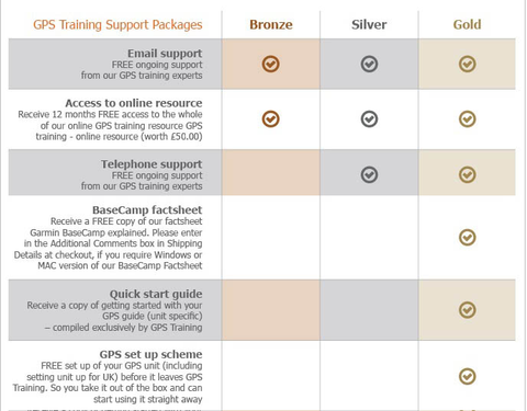
Includes Free Gold Support Package
- GPS Training review on the Garmin Montana 750i – The expert's view
The Garmin Montana is the same as the 700i except it comes with an 8mb built-in camera, which geotags where you have taken the pictures.
An easy-to-use GPS unit with a large touch screen and two-way satellite communication built-in, you can keep in contact with other people whilst off-grid.
If you want to see the Garmin Montana 700 series GPS unit in action, click on the 'Video' tab above and scroll down to the bottom video and let me take you on a 17-mile walk with the Garmin Montana 700. Get yourself a cup of tea first as it is 20 minutes long, but I will take you through the key features.
You will not be disappointed with the Garmin Montana 750i, a premium large-screen GPS unit.
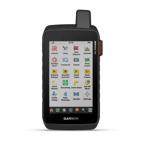
Overview of the Garmin Montana 750i
Rugged GPS Touchscreen Navigator with inReach Technology and 8 Megapixel Camera.
The rugged Montana 750i handheld combines the flexibility of on- or off-road navigation with global messaging and interactive SOS via inReach satellite technology — plus a built-in 8-megapixel camera.
Go into the wild with a satelite connection and large screen navigational GPS unit.
- Nav, meet cam. Put your trip pics on the map with geotags.
- A full QWERTY keyboard lets you easily type messages.
- Wander wider and still stay in touch — with inReach for messaging and 24/7 SOS.
- Expect big things - A large touchscreen puts them all at your fingertips.
- Routable TopoActive Europe maps - Now you’re free to take it off-road or on (See FAQ's tab).
- Meets MIL-STD 810 for thermal, shock, water and vibration.
- Get the clear perspective of BirdsEye Satellite Imagery right to your device.
- Go far with no fear. ABC sensors and multiple GNSS networks have your back.
- Power your adventures with 18+ hours of lithium-ion battery life in GPS mode.
N.B. InReach subscription required for Satellite messaging & SOS function, please see our FAQ's tab.
----- ONLY AVAILABLE WHEN YOU PURCHASE YOUR GPS FROM GPS TRAINING -----
PLUS - We don't just sell you a box with a GPS unit in. In with the price we teach you how to use it via our online training course (online resource), give you free factsheets and training manuals (in with your unit) and are only ever an email or telephone call away if you ever need any help.
PLUS - All GPS units are kept in stock and are sent out Royal Mail Special Delivery, so it will be with you the next working day.
PLUS - We also will take your old GPS as a trade-in, to get a value for your GPS unit please click here.
Buy and Learn from the experts - GPS Training.
With this GPS purchase, you get our 'gold' support package for 1 year at no extra cost (see below) - worth £145.00

Features
BUILT-IN CAMERA
Capture images of your exploits with Montana’s digital 8-megapixel camera. It geotags photos with coordinates, so you can navigate back to favourite sites in the future.
TWO-WAY MESSAGING
Exchange text messages with loved ones, post to social media, or communicate via inReach device to inReach device in the field (active satellite subscription required).
INTERACTIVE SOS
In case of emergency, trigger an interactive SOS message to GEOS, a professional 24/7 global monitoring and response centre (active satellite subscription required).
GLOBAL CONNECTIVITY
Instead of relying on cellphone coverage, now your messages, SOS and tracking are transferred via the 100% global Iridium® satellite network (active satellite subscription required).
INREACH WEATHER
Available inReach weather forecast service provides detailed updates directly to your Montana handheld or paired devices, so you’ll know what to expect en route.
RUGGED BY DESIGN
This durable, water-resistant handheld is tested to U.S. military standards and features a glove-friendly 5” touchscreen that’s 50% larger than previous Montana models.
TOPOACTIVE EUROPE MAPS
To navigate your adventures, use preloaded TopoActive Europe maps. View elevations, coastlines, rivers, landmarks and more.
SATELLITE VIEWS
Use direct-to-device downloads of BirdsEye Satellite Imagery (no annual subscription required) to see photo-realistic views and create waypoints based on landmarks.
ABC SENSORS
Navigate your next trail with ABC sensors, including an altimeter for elevation data, barometer to monitor weather and 3-axis electronic compass.
ACTIVE WEATHER
Use cellular connectivity1 to access up-to-date Active Weather forecasts through the Garmin Connect™ app.
DOG TRACKING
This Montana syncs with compatible Atemos series handhelds (sold separately) to help track dogs in the field.
MULTI-GNSS SUPPORT
Access to GPS, GLONASS and GALILEO satellite networks enables Montana® 700 to track in more challenging environments than GPS alone.
LOCATION SHARING
The LiveTrack feature lets you wirelessly connect1 your device with other compatible Garmin GPS users, so they can follow your tracks, routes, waypoints and adventures.
EXPEDITION MODE
Trek far and wide off-grid. Use Expedition mode, an ultralow-power GPS reference, to keep Montana tracking for a week or more between recharges.
BATTERY OPTIONS
An internal, rechargeable lithium-ion battery pack provides more than 18 hours of battery life in GPS mode.
VEHICLE MOUNTS
A variety of Montana handheld-compatible mounts (sold separately) lets you adapt your navigator for use on ATVs, boats, cars, motorcycles, RVs or other vehicles.
Specs
General |
|
| PHYSICAL DIMENSIONS | 9.19 x 18.30 x 3.27 cm |
|---|---|
| TOUCHSCREEN |  |
| DISPLAY SIZE | 6.48 x 10.80 cm; 5" diag (12.70 cm) |
| DISPLAY RESOLUTION | 480 x 800 pixels |
| DISPLAY TYPE | WVGA transflective, dual orientation |
| WEIGHT | 410 g with included lithium-ion battery pack |
| BATTERY TYPE | rechargeable lithium-ion (included) |
| BATTERY LIFE | GPS Mode: up to 18 hours Expedition Mode: up to 330 hours GPS Mode, 10 min Tracking: up to 18 hours Expedition Mode, 30 min Tracking: up to 300 hours |
| WATER RATING | IPX7 |
| MIL-STD-810 | yes (thermal, shock, water, vibe) |
| HIGH-SENSITIVITY RECEIVER | |
| INTERFACE | High speed micro USB and NMEA 0183 compatible |
| MEMORY/HISTORY | 16 GB (user space varies based on included mapping) |
Maps & memory |
|
| PRELOADED MAPS | Yes (TopoActive Europe) |
|---|---|
| ABILITY TO ADD MAPS | |
| BASEMAP | |
| AUTOMATIC ROUTING (TURN BY TURN ROUTING ON ROADS) | Yes (with optional mapping for detailed roads) |
| MAP SEGMENTS | 15000 |
| BIRDSEYE | Yes (direct to device) |
| INCLUDES DETAILED HYDROGRAPHIC FEATURES (COASTLINES, LAKE/RIVER SHORELINES, WETLANDS AND PERENNIAL AND SEASONAL STREAMS) | |
| INCLUDES SEARCHABLE POINTS OF INTERESTS (PARKS, CAMPGROUNDS, SCENIC LOOKOUTS AND PICNIC SITES) | |
| DISPLAYS NATIONAL, STATE AND LOCAL PARKS, FORESTS, AND WILDERNESS AREAS | |
| STORAGE AND POWER CAPACITY | Yes (32 GB max microSD™ card) |
| WAYPOINTS/FAVOURITES/LOCATIONS | 10000 |
| TRACKS | 250 |
| TRACK LOG | 20000 points, 250 saved gpx tracks, 300 saved fit activities |
| ROUTES | 250, 250 points per route; 50 points auto routing |
| RINEX LOGGING | |
Sensors |
|
| GPS | |
|---|---|
| GALILEO | |
| BAROMETRIC ALTIMETER | |
| COMPASS | Yes (tilt-compensated 3-axis) |
| GPS COMPASS (WHILE MOVING) | |
Daily smart features |
|
| CONNECT IQ™ (DOWNLOADABLE WATCH FACES, DATA FIELDS, WIDGETS AND APPS) | |
|---|---|
| WEATHER | |
| VIRB® CAMERA REMOTE | |
| COMPATIBLE WITH GARMIN CONNECT™ MOBILE | |
| ACTIVE WEATHER | |
| SMART NOTIFICATIONS ON HANDHELD | |
Safety and tracking features |
|
| LIVETRACK | |
|---|---|
Outdoor recreation features |
|
| POINT-TO-POINT NAVIGATION | |
|---|---|
| COMPATIBLE WITH BASECAMP™ | |
| AREA CALCULATION | |
| HUNT/FISH CALENDAR | |
| SUN AND MOON INFORMATION | |
| XERO™ LOCATIONS | |
| GEOCACHING-FRIENDLY | yes (Geocache Live) |
| CUSTOM MAPS COMPATIBLE | yes (500 custom map tiles) |
| PICTURE VIEWER | |
| CAMERA | Yes (8 megapixel with autofocus; automatic geo-tagging) |
| LED BEACON FLASHLIGHT | |
inReach® Features |
|
| INTERACTIVE SOS | |
|---|---|
| SEND AND RECEIVE TEXT MESSAGES TO SMS AND EMAIL | |
| SEND AND RECEIVE TEXT MESSAGES TO OTHER INREACH DEVICE | |
| EXCHANGE LOCATIONS WITH OTHER INREACH DEVICE | |
| MAPSHARE COMPATIBLE WITH TRACKING | |
| VIRTUAL KEYBOARD FOR CUSTOM MESSAGING | |
| SEND WAYPOINTS TO MAPSHARE DURING TRIP | |
| SEND ROUTE SELECTION TO MAPSHARE DURING TRIP | |
| INREACH REMOTE COMPATIBLE | |
Two-way Radio Features |
|
| CONTACTS | |
|---|---|
Outdoor applications |
|
| COMPATIBLE WITH GARMIN EXPLORE™ APP | |
|---|---|
| GARMIN EXPLORE WEBSITE COMPATIBLE | |
| DOG TRACKING | yes (when paired to compatible dog track system) |
Connections |
|
| WIRELESS CONNECTIVITY | Yes (Wi-Fi®, Bluetooth®, ANT+®) |
|---|---|
In the box
In the Box
- Montana 750i
- Lithium-ion battery pack
- USB cable
- Documentation
Only from GPS Training you also get in the box:
- GPS Training getting started guide
- Getting started with Garmin BaseCamp factsheet
- Our 'gold' support package at no extra cost for 1 year - worth £145.00
Video
FAQ's
1. How much are the service plans for Garmin inReach products for the Garmin Montana 750i?
You can find these online here.
The video below explains the different consumer subscriptions that are available:
2. When do I choose and activate my inReach service plan
You do this online with Garmin as you register and set up your inReach Satellite Communicator.
3. Does the Garmin inReach work using mobile phone signal?
No, and communication (text messages and e-mail) is done using the global Iridium satellite coverage.
4. What are each of the map options available with the Garmin Montana 750i?
This unit has Topoactive mapping on the internal memory and so this option comes as standard with any option you purchase. (Eg, if you purchase TOPO Great Britain Pro 1:50k, you will also get Topoactive mapping on the internal memory)
– Garmin Montana 750i with Europe TOPO ACTIVE Mapping
Garmin TOPO ACTIVE mapping is a proper digital map, as you zoom in you get more information and as you zoom out you get less. BUT, it is not an Ordnance Survey map, therefore it does not differentiate between Bridleways and Footpaths, it just marks them as paths.
It covers 47 European countries, compiled using the community-generated OpenStreetMap (OSM) database. Coverage for: Albania, Andorra, Austria, Belarus, Belgium, Bosnia-Herzegovina, Bulgaria, Croatia, Cyprus, Czech Republic, Denmark, Estonia, Finland, France, Germany, Greece, Hungary, Iceland, Ireland, Italy, Kosovo, Latvia, Liechtenstein, Lithuania, Luxembourg, Macedonia, Malta, Moldova, Monaco, Montenegro, Netherlands, Norway, Poland, Portugal, Romania, Russia (Kaliningrad only), San Marino, Serbia, Slovakia, Slovenia, Spain, Sweden, Switzerland, Turkey, Ukraine, United Kingdom and the Vatican City.
– Garmin Montana 750i with TOPO Great Britain Pro 1:50k - v3 (2024) - latest version
This is full GB at 1:50k mapping on a map card, which sits in the back of the GPS unit.
The TOPO PRO means that it is the latest map card from Garmin, giving you off road turn by turn routing within the National Parks, this means you can select a location many miles ahead and the GPS will route you via the footpaths to get to that location (like a car sat nav does).
Outside National Parks the GPS will navigate you in a straight line from waypoint to waypoint.
Don’t worry, here at the GPS Training we set the unit up for you so you can easily use these features and we even include a quick start guide so you can quickly get up and running with your GPS unit.
– Garmin Montana 750i with TOPO Great Britain PRO 1:25k, 1:50k and 1:250k Ordnance Survey Map Card - v3 (2024) - latest version
This is full GB at 1:25k, 1:50k and 1:250k mapping on a map card, which sits in the back of the GPS unit. As you zoom in and out you pass through each of these three map sets.
The TOPO PRO means that it is the latest map card from Garmin, giving you off-road turn by turn routing within the National Parks, this means you can select a location many miles ahead and the GPS will route you via the footpaths to get to that location (like a car sat nav does).
Outside National Parks, the GPS will navigate you in a straight line from waypoint to waypoint.
Don’t worry, here at the GPS Training we set the unit up for you so you can easily use these features and we even include a quick start guide so you can quickly get up and running with your GPS unit.
4.1 Can you update the maps on the Ordnance Survey Map Card?
5. How do I access my free training that I get when I buy a GPS from GPS Training?
You will receive everything you need to access this in with your GPS.
You will receive a username and password so you can access the GPS online resource (online training course) 24 hours a day, 7 days a week.
6. What countries is the Active Weather alerts available in?
Active Weather is currently available in United Kingdom, Ireland, Portugal, Spain, France, Germany, Belgium, Holland, Luxembourg, Switzerland, Denmark, Norway, Sweden, Finland, Austria and Slovenia, with partial coverage of the North Italy.
7. What battery charge options are available for the Garmin Montana 750i?
You can see the battery options available for the Garmin Montana 750 that have been in this video online here.
8. I want to use this Montana 750i GPS unit on a motorbike for trail riding, is there anything I need to know.
On our website, we have an in-depth review of the Garmin Montana 750i for trail riding.
9. What happens when you trigger the SOS alert button on your Montana 750i?
10. Does the inReach work in every country?
inReach devices operate on the Iridium satellite network, which provides 100% global coverage. However, some countries require prior permission for the authorized use of a satellite communication device and some countries have banned the use of satellite communications devices. In addition, United States embargoes prohibit providing satellite communications products and services in some countries.
The list below provides our best understanding of countries that may regulate or prohibit the use of a satellite communicator or are on a list of U.S. embargoed countries:
- Taliban controlled Afghanistan
- Crimea region of the Ukraine
- Cuba
- Georgia (SMS)
- India
- Iran
- North Korea
- Myanmar
- Sudan
- Syria
- Thailand
- Vietnam
- China
- Russia
*Regulations and the list above may change without notice. It is important to review the restrictions for satellite communicators for any country you may be travelling to in order to avoid issues for using or carrying an inReach satellite communication device. Your travel destination may have recently changed its laws or policies for various reasons. The US State Department has a list of foreign embassies and consulates that you can contact for more information.
NOTE: SMS messages to Telecom Personal Argentina or Georgia (country) subscribers cannot be delivered as there is currently no route available to this carrier through our international SMS delivery partner. Ghana does not currently have SMS messaging. Currently, there is also an issue with inReach messages being received by SMS phone numbers in Mexico and Romania. For more details, see - inReach Messages Not Received by SMS Phone Numbers in Mexico and inReach Messages Not Received by SMS Phone Numbers in Romania.
11. What are the main differences between the different two-way Satellite communicators that we stock?