
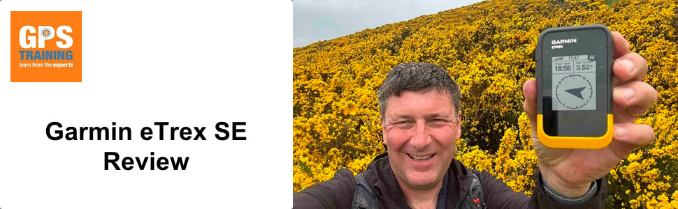

Garmin eTrex SE Review
Are you are looking for a cost effective, accurate, robust handheld GPS device with excellent battery life, to use on your hikes, trail runs & walks for backup to use alongside your paper maps, the Garmin eTrex SE is a great choice to look at.
The Garmin eTrex SE GPS device is a replacement for the very popular eTrex 10, the eTrex10 was released way back in 2011 as a budget robust monochrome screen device and was always a popular seller due to its budget price, decent battery life and robustness.
We have waited 12 years for a replacement to the eTrex 10, was it worth the wait?
Garmin eTrex SE Key Features
The Features marked as NEW were not available on the predecessor eTrex 10.
NEW - Multi-GNSS Support – unlike the eTrex 10 that could lock onto GPS & Glonass Satellites the new eTrex SE device can lock onto GPS, GLONASS, Galileo, BeiDou & QZSS satellite systems, this can give a much quicker and more accurate position fix especially in more challenging environments.
NEW – Improved Battery Life – like its predecessor the eTrex 10 the new eTrex SE is powered from a simple set of 2 x AA batteries, the big difference is that compared to the eTrex 10 battery life of 25hrs, the eTrex SE with a set of good quality AA batteries can achieve up to 168hrs in standard tracking mode.
NEW - Digital Compass – unlike its predecessor the eTrex SE boasts an electronic 3-axis compass, this provides an accurate compass heading and aligns your route navigation up even when stationary.
NEW - Garmin Explore App – using the Garmin Explore mobile app you can now transfer GPX files (Routes, Tracks etc) to the eTrex SE device without the need for a computer which you did need with the previous eTrex 10 device.
The app also allows for route planning using Garmin Topo Maps, syncing of weather data and phone notifications to your eTrex SE and also syncs your GPS location from the eTrex SE device to offline maps on the Explore App.
NEW - Live Geocaching – When paired with the Garmin Explore App and with mobile data you can download the closest 25 x Geocaches to where you are without the need for a computer once they are on your eTrex SE device you do not need mobile data.
(You can still transfer GPX Geocache files to the device using a computer & usb cable connection)
NEW - Active Weather – When paired with the Garmin Explore app and mobile data on your phone you can sync up to date weather data to the eTrex SE device.
NEW - High Contrast Display – The increased pixels 240 x 320 and improved contrast really improve the viewing of the screen on this Sunlight readable display.
Water resistant – Carrying on from the eTrex 10 unit the eTrex SE device also has a high weather rating of IPX7 – Hike & Trail Run in any weather.
What is the eTrex SE device like to use, our own personal experiences.
We have been using the eTrex SE device since its launch in March 2023 and have been very impressed on what this tough compact device has to offer.
Explore App
The first key thing for us with the eTrex SE device is that you no longer need a computer to transfer routes to the device, we have become so used to using mobiles apps to transfer data to the newer generation Garmin Handhelds & Watches, it was great to see this feature within a budget unit, with the older eTrex models you do needed a computer to transfer data over which not everyone owns.
The mobile app that is used to sync your GPX routes over to the eTrex SE device is called Garmin Explore, the app can be installed on either an Android phone running 6.0 OS or later & Bluetooth 4.0 or later or on an iPhone / iPad running iOS 13.0 or later.
Once you get into the app and understand about creating collection folders to import your GPX files to, we found the process straight forward to get GPX files from your mobile phone to the eTrex SE device.
We do like that once you have GPX files downloaded to your phone is that you do not need mobile data on your phone to then import the GPX files that you already have on your phone to the app and send them to your device, other apps such as Garmin Connect do require mobile data to transfer to compatible devices.
The more that we got into using the eTrex SE device we started to use the Explore App a lot more alongside the device for showing our location on the Explore app offline maps and also to show our course line displayed on the Explorer App map, we soon realized that using the app in this way uses the eTrex SE to its full potential.
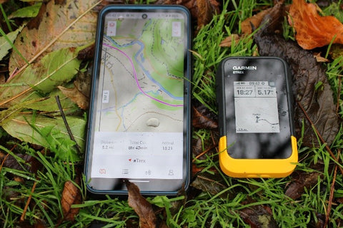
You can download offline Maps to the Explore app and then if you are in a situation where you have no mobile phone data, you can still with the Explore App open on your phone display your downloaded Garmin Topo offline maps and on these maps with the eTrex SE paired and the app set to sync current activity and tracking started on the eTrex SE, you can view your current position on the map using the GPS location transmitted from the actual eTrex SE device itself.
In our tests to save battery on our phone we put our phone into Aeroplane mode and turned Bluetooth only back on, we only brought on our phone screen with the Explore map for a short time, just to confirm a location or course line on the Garmin Map but we did find this feature really useful as the eTrex SE device itself does not have maps on its monochrome screen.
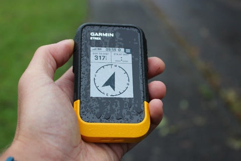
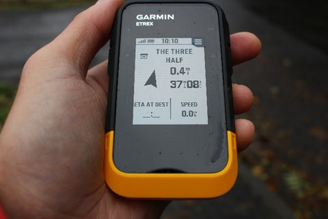
Also using the Map screen on the Explore app you can simply tap on a location on the map that you would like to aim for and then on the screen of the eTrex SE this direct goto line will display and you can also simply use the compass pointer on your eTrex SE device with distance to the destination displayed to navigate to the single point.

You can also load up a route that you have saved within the Explore app, start the navigation from the app and then see this route synced across and loaded on the screen of the eTrex SE to follow.
Using the eTrex SE to Navigate with
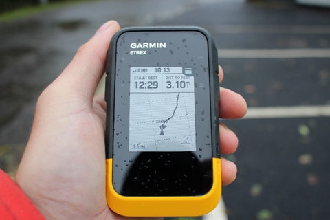
Once you have your course loaded onto the device via the Explore App and your navigation started you have a simple black course line to follow, your position is shown on the map as a black triangle on the screen and you can see the black course line to follow, setting up the device to track up means as you orientate the map turns with you to your direction of travel, with the electronic compass this works even when stationary.
N.B. If you prefer you can set the map to North Up and then the black position triangle will point in the direction that you are heading in.
Although not having mapping on the device itself can be a miss especially if you need to deviate from your planned course, but one thing we did find is how clear it is to view your course line, especially in bright sunlight the screen works very well.
If you want to view your current location and course line on a map, as per our overview above on the Explore App, it was easy enough to quickly open the Explore app on your phone and with the eTrex SE syncing your current activity you can view your location on the Garmin Topo maps.
The maps are not as detailed as the Ordnance Survey Maps that we are so used to using in the UK, but it was still nice to be able to see you location displayed on a Topographic map when needed.
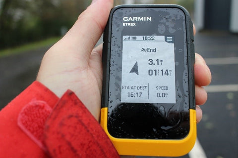
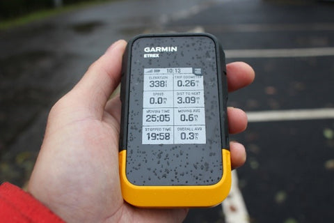
When navigating a Course or to a single point goto as well as the map screen with a black course line displayed, you also have access to either a simple pointer screen displaying the direction of travel that you need to go in with distance to destination displayed or you can bring up a trip computer page with databoxes displaying lots of useful information such as elevation data, trip distance, speeds etc, eta information.
Another great feature is that when you start tracking to record your activity on the eTrex SE, at any time you can select an option to TrackBack to the start as a breadcrumb trail, the eTrex SE device then displays a course line following your exact breadcrumb trail back to the start of your activity.
If you deviate from your course there is an off-course alert message appears on the top of your screen, but with no tone or vibration option available on the eTrex SE device this alert can get missed.
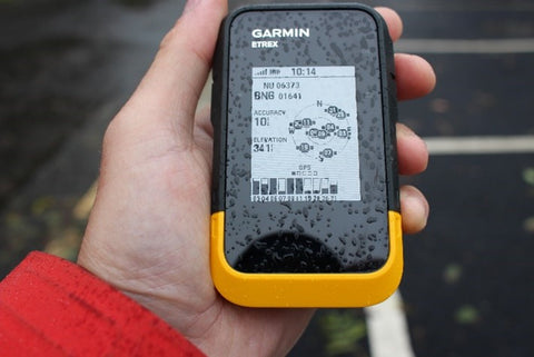
Finally when using the device to Navigate with you can quickly access a Satellite Page that as well as displaying your Satellite accuracy it also displays your current location Grid Reference, there are many different position format options to choose from, in Great Britain I was using ‘British National Grid’ to display an ordnance survey grid reference on my eTrex SE device, to then cross refer with an Ordnance Survey paper map.
Route Planning
You can easily plan routes directly on the Garmin Explore App to transfer straight over to the unit, but with the Maps on the Explore App not being as detailed as Ordnance Survey maps, we often plan our own hiking routes on our free to use GPS Training Ordnance Survey Route Planner or on 3rd party map apps using more detailed mapping.
When we have planned routes on our easy and free to use GPS training OS Route Planner, we simply emailed them over to ourselves and then from the email on our mobile phone simply opened up the GPX file using the Garmin Explore App to transfer to the eTrex SE.


You can access our free to use OS Route Planner here
If you have been sent a GPX file for an event, you can simply import the GPX file into the Garmin Explore app to then transfer straight to your eTrex SE device.
N.B. We did find that if the GPX file you imported was showing as either a Route or Track in the Explore App, that it was better to convert it to a course first using Explore App which was a simple process and then sync the course only to the eTrex SE, this method seemed to sync the GPX file to the eTrex SE much quicker.
Geocaching with the eTrex SE
We have been using the eTrex SE for Geocaching via the live Geocache download option when paired with the Explore Mobile App.
We have been using the free Basic Member Geocaching account and not a premium account, with the eTrex SE paired with the Explore app and mobile data on our phones it was easy to register the eTrex SE with our Geocaching account and then download the closest 25 x Geocaches to our current location.
The navigational experience was the same as described in our Navigation overview above, once you load up one of the downloaded Geocaches, you get a black course line on the screen of the eTrex SE taking you to the Geocache, you can also view a directional arrow pointer with distance to the cache displayed.
As per course navigation, you can with your eTrex SE device syncing your current activity to the Garmin Explore App, view your course line to the cache on the Garmin Explore Apps offline Topo Map.
You can on the eTrex SE easily log your attempts to find the cache, which will then sync when you have mobile data to your Geocaching online account via the Garmin Explore App connection.
If you are a premium Geocache member you can view detailed descriptions for the Caches, as a non-premium Geocache member you can download up to 3 x Geocache descriptions a day to the eTrex SE.

The only downside with the live Geocaching download method using the Explore App is that to initially download the caches you do need either mobile data or Wi-Fi connection on your phone and you only can download the closest 25 x Geocaches to where you currently have a GPS signal with the device.
Once the caches are on your eTrex SE you can put your phone away and mobile data is no longer required unless you need to download more caches as you change location.
This is still a great way to get started with Geocaching and using the robust weatherproof eTrex SE with great battery life you do not need to worry about damaging your phone when out searching.
With your eTrex SE device connected to a computer you can still transfer Geocaches via a USB-C connection not your device and using Garmin Express software on a computer, if using a Windows PC you can manually copy Geocache GPX files to the GPX folder on the device using file explorer. (NB On a Mac computer the eTrex SE is not detected as an external drive hence Garmin Express software would be required to send Geocaches over)
Our Conclusion
The Garmin eTrex SE is a great unit when on a budget but wanting an accurate robust, weatherproof GPS device with great battery life, to use as backup alongside your paper maps.
With its exceptional battery life we found the eTrex SE a great backup device to carry on our hikes and long distance ultra events that we have taken part in, including the likes of the Montane Spine Challenger event.
Being able to send routes to the eTrex SE unit without the need for a computer and via the mobile phone app is a big bonus, also having the option to see your location on an offline map on the Garmin Explore App without the need for any Mobile phone signal is great, albeit not as detailed as Ordnance Survey Maps.
We found that with the eTrex SE GNSS multiband receiver that satellite lock was very quick and a great position accuracy of around 10ft (3metres) can be achieved.
The back to start trackback function has always been one of our favourite features on a handheld device and this function works very well on the eTrex SE showing you a clear precise breadcrumb trail as a black course line back to the start of your activity.
We would have liked to have had a tone or vibration alert on the eTrex SE otherwise we have been very happy with the unit and how it has performed for us.
In this price range of under £150.00 the eTrex SE is a great unit with some fantastic features.
With a purchase of a GPS Device from GPS training our Gold Support package worth £145.00 is included, as well as email & telephone support our Gold Support package also includes access to all our Online training videos to get you to grips with your eTrex SE device & Garmin Explore App.
Further reading
1. For more information on the eTrex SE device - More info here
2. We have a great video showing the eTrex SE being used, a 'walk and talk' – More info here
3. The training videos available via this link will give you a taster to all of the other videos that are available to you on our Online Training resource that get free access to if you purchase a eTrex SE from us - Training videos taster
(Our online training resource currently has 39 x Videos that cover the eTrex SE)