- GPS Training review on the Garmin GPSMAP 65s - the expert's view -
The Garmin GPSMAP 65s is the updated version of the Garmin 64s.
The case size is identical, but the Garmin GPSMAP 65s is a multi-band GPS unit, meaning it is one of the most accurate handheld GPS units on the market.
You can also transfer routes directly onto the Garmin GPSMAP 65s using the explore app, therefore taking the PC/ Mac out of the equation.
I personally think it is one of the best GPS units on the market, with the slightly smaller screen (compared to the 66s series) you get great battery life so ideal for the high-level four-season walker.
Trade-in your old GPS or GPS watch
Upgrade to this model for less. Get an instant trade-in estimate in minutes.
Explore the world with reliable navigation in hand
Don’t miss a detail with this large, sunlight-readable colour display.
Lead the way in challenging locations with multi-band technology and expanded GNSS satellite support.
Plot your next move with built-in navigation sensors.
Organise your adventure from anywhere with the Garmin Explore website and app
Travel with up to 16 hours of battery life in GPS mode.
Please call - 01669 621044 - and speak with one of our friendly GPS experts.
----- ONLY AVAILABLE WHEN YOU PURCHASE YOUR GPS FROM GPS TRAINING -----
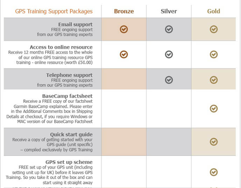
PLUS - We don't just sell you a box with a GPS unit in. In with the price we teach you how to use it via our online training course (online resource), give you free factsheets and training manuals (in with your unit) and are only ever an email or telephone call away if you ever need any help.
PLUS -All GPS units are kept in stock and are sent out Royal Mail Special Delivery, so it will be with you the next working day.
PLUS - We also will take your old GPS as a trade-in, to get a value for your GPS unit please click here.
Buy and learn from the experts at GPS Training
With this GPS purchase, you get our 'Gold' Support Package for 1 year at no extra cost.
Multi-band technology and expanded GNSS support (GPS, GLONASS, Galileo, QZSS and IRNSS) provide optimal accuracy in steep country, urban canyons and forests with dense trees.
ABC SENSORS
Navigate every trail with ABC sensors, including an altimeter for elevation data, barometer to monitor weather and 3-axis electronic compass.
PRELOADED TOPOACTIVE EUROPE MAPS
Preloaded TopoActive Europe maps provide detailed views of routable street and off-road networks, waterways, natural features, land use areas, buildings and more (See FAQ's tab).
SMART NOTIFICATIONS
Receive emails, texts and alerts right on your handheld when paired with your compatible device.
GARMIN EXPLORE APP
Plan, review and sync waypoints, routes and tracks by using the Garmin Explore app1 and website. You can even review completed activities while still in the field.
GEOCACHING
Get automatic cache updates from Geocaching Live, including descriptions, logs and hints.
MICRO SD SLOT
Using your compatible device and microSD memory card, conveniently download TOPO 24K maps and hit the trail.
Specs
PHYSICAL DIMENSIONS
6.1 x 16.0 x 3.6 cm
DISPLAY SIZE
3.6 x 5.5 cm; 2.6-inch diagonal (6.6 cm)
DISPLAY RESOLUTION
160 x 240 pixels
DISPLAY TYPE
Transflective, 65K colour TFT
WEIGHT
217 g with batteries
BATTERY TYPE
2 AA batteries (not included); NiMH or Lithium recommended
BATTERY LIFE
16 hours
WATER RATING
IPX7
HIGH-SENSITIVITY RECEIVER
Yes
INTERFACE
High-speed mini USB and NMEA 0183 compatible
MEMORY/HISTORY
16 GB (user space varies based on included mapping)
Maps & memory
PRELOADED MAPS
Yes (TopoActive Europe; routable)
ABILITY TO ADD MAPS
Yes
BASEMAP
Yes
AUTOMATIC ROUTING (TURN BY TURN ROUTING ON ROADS)
Yes
MAP SEGMENTS
3,000
BIRDSEYE
250 BirdsEye Imagery files
INCLUDES DETAILED HYDROGRAPHIC FEATURES (COASTLINES, LAKE/RIVER SHORELINES, WETLANDS AND PERENNIAL AND SEASONAL STREAMS)
Yes
INCLUDES SEARCHABLE POINTS OF INTERESTS (PARKS, CAMPGROUNDS, SCENIC LOOKOUTS AND PICNIC SITES)
Yes
DISPLAYS NATIONAL, STATE AND LOCAL PARKS, FORESTS, AND WILDERNESS AREAS
Yes
STORAGE AND POWER CAPACITY
Yes (32 GB max microSD™ card)
WAYPOINTS/FAVOURITES/LOCATIONS
5,000
TRACKS
200
TRACK LOG
10,000 points, 200 saved tracks
ROUTES
200, 250 points per route; 50 points auto routing
Sensors
GPS
Yes
GLONASS
Yes
GALILEO
Yes
BAROMETRIC ALTIMETER
Yes
COMPASS
Yes (tilt-compensated 3-axis)
GPS COMPASS (WHILE MOVING)
Yes
Daily smart features
VIRB® CAMERA REMOTE
Yes
COMPATIBLE WITH GARMIN CONNECT™ MOBILE
Yes
SMART NOTIFICATIONS ON HANDHELD
Yes
Outdoor recreation features
POINT-TO-POINT NAVIGATION
Yes
COMPATIBLE WITH BASECAMP™
Yes
AREA CALCULATION
Yes
HUNT/FISH CALENDAR
Yes
SUN AND MOON INFORMATION
Yes
GEOCACHING-FRIENDLY
Yes (paperless)
CUSTOM MAPS COMPATIBLE
yes (500 custom map tiles)
PICTURE VIEWER
Yes
Outdoor applications
COMPATIBLE WITH GARMIN EXPLORE™ APP
Yes
GARMIN EXPLORE WEBSITE COMPATIBLE
Yes
Connections
WIRELESS CONNECTIVITY
Yes - Bluetooth®, ANT+®
In the box
In the Box
- Garmin GPSMAP 65s
- USB cable
- Carabiner clip
- Documentation
Only from GPS Training you also get in the box:
- GPS Training getting started guide
- Getting started with Garmin BaseCamp factsheet
- Our 'gold' support package at no extra cost for 1 year - worth £145.00
Video
FAQ's
1. What are each of the map options available with the Garmin GPSMAP 65s?
This unit has Topoactive mapping on the internal memory and so this option comes as standard with any option you purchase. (Eg, if you purchase TOPO Great Britain Pro 1:50k, you will also get Topoactive mapping on the internal memory)
– Garmin GPSMAP 65s with Europe TOPO ACTIVE Mapping
Garmin TOPO ACTIVE mapping is a proper digital map, as you zoom in you get more information and as you zoom out you get less. BUT, it is not an Ordnance Survey map, therefore it does not differentiate between Bridleways and Footpaths, it just marks them as paths.
It covers 47 European countries, compiled using the community-generated OpenStreetMap (OSM) database. Coverage for: Albania, Andorra, Austria, Belarus, Belgium, Bosnia-Herzegovina, Bulgaria, Croatia, Cyprus, Czech Republic, Denmark, Estonia, Finland, France, Germany, Greece, Hungary, Iceland, Ireland, Italy, Kosovo, Latvia, Liechtenstein, Lithuania, Luxembourg, Macedonia, Malta, Moldova, Monaco, Montenegro, Netherlands, Norway, Poland, Portugal, Romania, Russia (Kaliningrad only), San Marino, Serbia, Slovakia, Slovenia, Spain, Sweden, Switzerland, Turkey, Ukraine, United Kingdom and the Vatican City.
– Garmin GPSMAP 65s with TOPO Great Britain Pro 1:50k - v3 (2024) - latest version
This is full GB at 1:50k mapping on a map card, which sits in the back of the GPS unit.
The TOPO PRO means that it is the latest map card from Garmin, giving you off road turn by turn routing within the National Parks, this means you can select a location many miles ahead and the GPS will route you via the footpaths to get to that location (like a car sat nav does).
Outside National Parks the GPS will navigate you in a straight line from waypoint to waypoint.
Don’t worry, here at the GPS Training we set the unit up for you so you can easily use these features and we even include a quick start guide so you can quickly get up and running with your GPS unit.
– Garmin GPSMAP 65s with TOPO Great Britain PRO 1:25k, 1:50k and 1:250k Ordnance Survey Map Card - v3 (2024) - latest version
This is full GB at 1:25k, 1:50k and 1:250k mapping on a map card, which sits in the back of the GPS unit. As you zoom in and out you pass through each of these three map sets.
The TOPO PRO means that it is the latest map card from Garmin, giving you off-road turn by turn routing within the National Parks, this means you can select a location many miles ahead and the GPS will route you via the footpaths to get to that location (like a car sat nav does).
Outside National Parks, the GPS will navigate you in a straight line from waypoint to waypoint.
Don’t worry, here at the GPS Training we set the unit up for you so you can easily use these features and we even include a quick start guide so you can quickly get up and running with your GPS unit.
1.1 Can you update the maps on the Ordnance Survey Map Card?
2. Does the Garmin GPSMAP 65s come with batteries?
As per our answer to question 1, the GPSMap65s unit is powered by 2 x AA Batteries, with good quality batteries as shown in our Video above you can achieve up to 16hrs battery life.
4. Is the Garmin GPSMap 65s a good GPS unit for all season use?
The Garmin GPSMap 65s is a great rugged unit for using in all weathers due to its good size buttons which can be used with gloves on, ingress protection rating of IPX7 offering great weather protection and has a Trans Reflective sunlight readable colour screen.
5. Is the Garmin GPSMap 65s a good unit ?
The Garmin GPSMAP65s is a great reliable, rugged all season GPS unit from Garmin. It is an updated version of the Garmin GPSMAP64sx with multi-band/ multi-GNSS handheld with sensors giving improved accuracy and a very quick Satellite lock.. It also works alongside the Garmin Explore app so you can transfer routes/ tracks directly onto this unit without the use of a PC/ Mac. The electronic compass on this version aligns the maps up to your direction of travel even when stationary and also has a Barometric Altimeter for displaying height data.
6. Can you use the Garmin GPSMap65s on a Bicycle ? Yes you can there is a bike bar mount available for the Garmin GPSMap65s here and the pre-loaded Topo Active Mapping covering all of Europe has turn by turn routable data suitable for cycling.