- GPS Training review on the GarminGPSMAP67i- the expert's view -
The GarminGPSMAP 67i is currently one of the best-selling GPS unit from Garmin, and there is a reason for that, it is the best four-season GPS unit on the market.
The Garmin GPSMAP 67i has Garmin 'inReach' technology built in. This enables you to send/ receive text messages via the satellites and also to enable live tracking if you choose to.
With the staggering battery life and ease of use, you get with the Garmin GPSMAP67i you will not be disappointed.
Trade-in your old GPS or GPS watch
Upgrade to this model for less. Get an instant trade-in estimate in minutes.
GO EXPLORE THE OUTDOORS - AND STAY CONNECTED TO HOME
Make more time for adventure with this premium, rugged handheld GPS and satellite communicator. Get inReach® technology that enables two-way messaging, interactive SOS alerts and location sharing1 plus mapping to keep you on course.
-Travel longer with up to 165 hours of battery life in tracking mode and up to 425 hours in expedition mode.
-Two-way messaging lets you share the moment with the ones who matter.
-Let your loved ones follow your adventure with location tracking.
-Have an emergency? Trigger an interactive SOS alert anytime, globally.
-Track your position in challenging conditions with multi-band technology and expanded GNSS support.
N.B. InReach subscription is required for Satellite messaging & SOS function, please see our FAQ's tab.
What is the best Garmin inReach plan for you? Please check out our Garmin inReach cost calculator (opens in a new window).
Please call - 01669 621044 - and speak with one of our friendly GPS experts.
----- ONLY AVAILABLE WHEN YOU PURCHASE YOUR GPS FROM GPS TRAINING -----
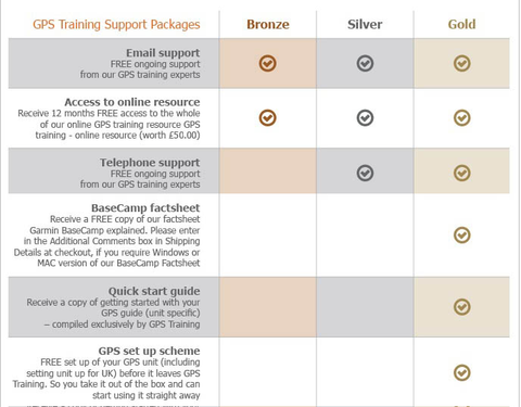
PLUS - We don't just sell you a box with a GPS unit in. In with the price we teach you how to use it via our online training course (online resource), give you free factsheets and training manuals (in with your unit) and are only ever an email or telephone call away if you ever need any help.
PLUS -All GPS units are kept in stock and are sent out Royal Mail Special Delivery, so it will be with you the next working day.
PLUS - We also will take your old GPS as a trade-in, to get a value for your GPS unit please click here.
Buy and learn from the experts at GPS Training
With this GPS purchase, you get our 'Gold' Support Package for 1 year at no extra cost.
MULTI-BAND GNSS SUPPORT Access multiple global navigation satellite systems (GPS, Galileo and BEIDOU). Get access to multiple frequencies sent by navigation satellites for improved position accuracy in areas where GNSS signals are reflected, weak or typically don't penetrate.
ABC SENSORS Navigate every trail with ABC sensors, including an altimeter for elevation data, barometer to monitor weather and 3-axis electronic compass.
SATELLITE IMAGERY Download high-resolution photorealistic maps directly to your device via Wi-Fi® technology. Easily find trails, pick stand locations and parking, create waypoints and more.
PRELOADED TOPOACTIVE EUROPE MAPS Preloaded TopoActive Europe maps show you summits, parks, coastlines, rivers, lakes and geographical points.
PREMIUM MAP FEATURES With an Outdoor Maps+ subscription, you get public land information, landowner names, state plat maps, BLM boundaries and more. (USA Only)
BATTERY LIFE Turn on expedition mode, and get up to 425 hours of battery life while using inReach technology. In the default tracking mode, you get up to 165 hours of battery life, and your device will save your location every 10 minutes.
Keep in touch on the trail.
TWO-WAY MESSAGING Exchange text messages with loved ones, post to social media, or communicate from inReach to inReach in the field.
INTERACTIVE SOS ALERTS In case of emergency, trigger an interactive SOS message to the Garmin ResponseSM centre, a 24/7-staffed professional emergency response coordination centre.
LOCATION SHARING Track your location and share it with those at home or out in the field. They'll be able to see your progress or ping your device for your GPS location and more.
100% GLOBAL IRIDIUM® SATELLITE NETWORK Instead of relying on mobile phone coverage, now your messages, SOS alerts and tracking are transferred via the global Iridium satellite network.
GARMIN MESSENGER™ APP Download the Garmin Messenger app to your compatible smartphone, and pair it with your GPSMAP® 67i handheld GPS for fast, easy messaging and 24/7 SOS that's not limited to mobile phone coverage areas1. The app supports group messaging as well.
GARMIN EXPLORE™ APP Plan, review and sync waypoints, routes and tracks by using the Garmin Explore app and website. You can even review completed activities while still in the field.
OPTIONAL INREACH WEATHER Use inReach connectivity to get detailed weather updates on the GPSMAP 67i handheld GPS. Request weather forecasts for your current location, waypoints or destinations on your route.
ACTIVE WEATHER When connected to the Garmin Explore smartphone app , you can get real-time forecast information, so you're aware of the changing conditions.
BUILT FOR ADVENTURE This handheld is built to military standards for thermal, shock and water performance (MIL-STD-810), and it's even compatible with night vision goggles.
LED FLASHLIGHT The GPSMAP 67 series handheld helps you keep gear to a minimum with a built-in LED flashlight that can be used as a beacon to signal for help.
GEOCACHING Get automatic cache updates from Geocaching Live, including descriptions, logs and hints. When connected via Wi-Fi technology or to the Garmin Explore™ smartphone app, each find will upload to your Geocaching.com profile.
1 Satellite subscription required. Some jurisdictions regulate or prohibit the use of satellite communication devices. It is your responsibility to know and follow all applicable laws in the jurisdictions where the device is intended to be used.
Up to 165 hours with inReach® enabled with 10 minute tracking Up to 180 hours in GPS Mode Up to 425 hours in Expedition mode with inReach enabled Up to 425 hours in expedition mode
MIL-STD-810
Yes (thermal, shock, water); bare unit only
INTERFACE
USB-C
MEMORY/HISTORY
16 GB (user space varies based on included mapping)
Maps & memory
PRELOADED MAPS
Yes (TopoActive Europe; routable)
ABILITY TO ADD MAPS
Yes
BASEMAP
Yes
AUTOMATIC ROUTING (TURN BY TURN ROUTING ON ROADS) FOR OUTDOOR ACTIVITIES
Yes
MAP SEGMENTS
15,000
SATELLITE IMAGERY
Yes (direct to device)
INCLUDES DETAILED HYDROGRAPHIC FEATURES (COASTLINES, LAKE/RIVER SHORELINES, WETLANDS AND PERENNIAL AND SEASONAL STREAMS)
Yes
INCLUDES SEARCHABLE POINTS OF INTERESTS (PARKS, CAMPGROUNDS, SCENIC LOOKOUTS AND PICNIC SITES)
Yes
DISPLAYS NATIONAL, STATE AND LOCAL PARKS, FORESTS, AND WILDERNESS AREAS
Yes
STORAGE AND POWER CAPACITY
Yes (32 GB max microSD™ card)
WAYPOINTS/FAVOURITES/LOCATIONS
10,000
COURSES
250, 200 course points per course
TRACKS
250
NAVIGATION TRACK LOG
20,000 points, 250 saved gpx tracks, 300 saved fit activities
What is the best Garmin inReach plan for you? Please check out our Garmin inReach cost calculator (opens in a new window).
The video below explains the different consumer subscriptions that are available:
2. When do I choose and activate my inReach service plan?
You do this online with Garmin as you register and set up your inReach Satellite Communicator.
3. Can you put your Garmin inReach account on hold or stop it for a period?
There are a couple of options to do this –
- inReach Enabled (Pay as you go type service)
This then costs - £7.99 per month and you get –
Unlimited SOS and messaging with Garmin Response
£0.10 per check-in message or reaction
£0.10 per tracking point
£0.50 per text message or weather forecast
- Suspend your plan – If you do this as long as you reactivate your service within 12 months there is no re-actication fee to pay, if you do not recativate within 12 months you then have to pay for the Activation fee again of £39.99.
What is the best Garmin inReach plan for you? Please check out our Garmin inReach cost calculator (opens in a new window).
4. Does the Garmin inReach work using mobile phone signal?
No, and communication (text messages and e-mail) is done using the global Iridium satellite coverage.
5. What are each of the map options available with Garmin GPSMAP 67i?
This unit has Topoactive mapping on the internal memory and so this option comes as standard with any option you purchase. (Eg, if you purchase TOPO Great Britain Pro 1:50k, you will also get Topoactive mapping on the internal memory)
– Garmin GPSMAP 67i with Western Europe TOPO ACTIVE Mapping
Garmin TOPO ACTIVE mapping is a proper digital map, as you zoom in you get more information and as you zoom out you get less. BUT, it is not an Ordnance Survey map, therefore it does not differentiate between Bridleways and Footpaths, it just marks them as paths.
It covers 47 European countries, compiled using the community-generated OpenStreetMap (OSM) database. Coverage for: Albania, Andorra, Austria, Belarus, Belgium, Bosnia-Herzegovina, Bulgaria, Croatia, Cyprus, Czech Republic, Denmark, Estonia, Finland, France, Germany, Greece, Hungary, Iceland, Ireland, Italy, Kosovo, Latvia, Liechtenstein, Lithuania, Luxembourg, Macedonia, Malta, Moldova, Monaco, Montenegro, Netherlands, Norway, Poland, Portugal, Romania, Russia (Kaliningrad only), San Marino, Serbia, Slovakia, Slovenia, Spain, Sweden, Switzerland, Turkey, Ukraine, United Kingdom and the Vatican City.
N.B. With the GPSMap67i series you can also install the following Garmin Topo Active Maps for other parts of the world free of charge TopoActive Japan, Africa, Antarctica, Australia & New Zealand, China Mainland, Greenland, Hong Kong, Korea, Middle East, North America, South America, Singapore/Malaysia/Vietnam/Philippines, Taiwan & Indonesia/Thailand.
These maps can be installed using Map Manager with Garmin Express on a computer or if you use Garmin Express to add your Wifi to the device they can be downloaded via wifi. (Additional storage may be required depending on the size of the map download, a 32gb size max micro card can be installed for this if required)
– Garmin GPSMAP 67i with TOPO Great Britain Pro 1:50k - v3 (2024) - latest version
This is full GB at 1:50k mapping on a map card, which sits in the back of the GPS unit.
The TOPO PRO means that it is the latest map card from Garmin, giving you off road turn by turn routing within the National Parks, this means you can select a location many miles ahead and the GPS will route you via the footpaths to get to that location (like a car sat nav does).
Outside National Parks the GPS will navigate you in a straight line from waypoint to waypoint.
Don’t worry, here at the GPS Training we set the unit up for you so you can easily use these features and we even include a quick start guide so you can quickly get up and running with your GPS unit.
– Garmin GPSMAP 67i with TOPO Great Britain PRO 1:25k, 1:50k and 1:250k Ordnance Survey Map Card - v3 (2024) - latest version
This is full GB at 1:25k, 1:50k and 1:250k mapping on a map card, which sits in the back of the GPS unit. As you zoom in and out you pass through each of these three map sets.
The TOPO PRO means that it is the latest map card from Garmin, giving you off-road turn by turn routing within the National Parks, this means you can select a location many miles ahead and the GPS will route you via the footpaths to get to that location (like a car sat nav does).
Outside National Parks, the GPS will navigate you in a straight line from waypoint to waypoint.
Don’t worry, here at the GPS Training we set the unit up for you so you can easily use these features and we even include a quick start guide so you can quickly get up and running with your GPS unit.
6. Can you update the Ordnance Survey Map Card?
7. What battery charge options are available for the Garmin GPSMAP 67i?
8. Can you change the replace the battery on the GPSMap67i unit?
9. Does the inReach work in every country?
inReach devices operate on the Iridium satellite network, which provides 100% global coverage. However, some countries require prior permission for the authorized use of a satellite communication device and some countries have banned the use of satellite communications devices. In addition, United States embargoes prohibit providing satellite communications products and services in some countries.
The list below provides our best understanding of countries that may regulate or prohibit the use of a satellite communicator or are on a list of U.S. embargoed countries:
Taliban controlled Afghanistan
Crimea region of the Ukraine
Cuba
Georgia (SMS)
India
Iran
North Korea
Myanmar
Sudan
Syria
Thailand
Vietnam
China
Russia
*Regulations and the list above may change without notice.It is important to review the restrictions for satellite communicators for any country you may be travelling to in order to avoid issues for using or carrying an inReach satellite communication device. Your travel destination may have recently changed its laws or policies for various reasons. The US State Department has alist of foreign embassies and consulatesthat you can contact for more information.
NOTE:SMS messages to Telecom Personal Argentina or Georgia (country) subscribers cannot be delivered as there is currently no route available to this carrier through our international SMS delivery partner. Ghana does not currently have SMS messaging. Currently, there is also an issue with inReach messages being received by SMS phone numbers in Mexico and Romania. For more details, see -inReach Messages Not Received by SMS Phone Numbers in MexicoandinReach Messages Not Received by SMS Phone Numbers in Romania.
10. What are the main differences between the different two-way Satellite communicators that we stock?