Marine handheld GPS with inReach satellite communication capabilities.
- Water-resistant, floating design, sunlight-readable 3" display and button operation provide ease of use on the water
- Stream boat data from compatible chartplotters and instruments to consolidate your marine system information
- Stay in touch with inReach satellite communication and two-way text messaging via the 100% global Iridium® satellite network (satellite subscription required)
- Functions as a remote control for convenient operation of your Garmin autopilot and select FUSION® marine products
- Supports optional BlueChart g3 charts
- Adjustable GPS filter smooths speed and heading indications over swells
Trade-in your old GPS or GPS watch
Upgrade to this model for less. Get an instant trade-in estimate in minutes.
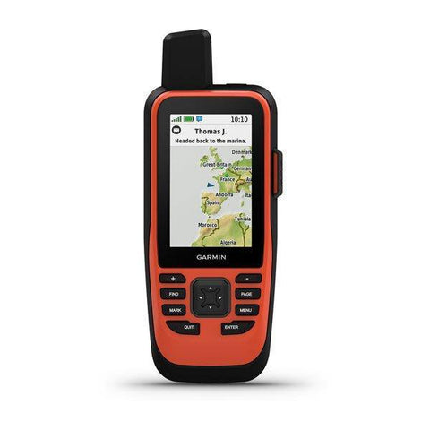
Cast off confidently with the GPSMAP® 86s handheld. Whether you’re out for a day of fishing, sailing or cruising, you’ll gain peace of mind that comes from having a backup navigator. This premium handheld floats and has a sunlight-readable 3” colour display. Plus, wireless connectivity makes it a virtual extension of your onboard marine system, giving you added awareness and convenience.
Please call - 01669 621044 - and speak with one of our friendly GPS experts.
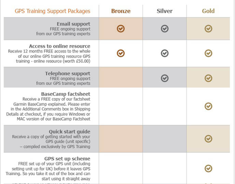
----- ONLY AVAILABLE WHEN YOU PURCHASE YOUR GPS FROM GPS TRAINING -----
PLUS - We don't just sell you a box with a GPS unit in. In with the price we teach you how to use it via our online training course (online resource), give you free factsheets and training manuals (in with your unit) and are only ever an email or telephone call away if you ever need any help.
PLUS -All GPS units are kept in stock and are sent out Royal Mail Special Delivery, so it will be with you the next working day.
PLUS - We also will take your old GPS as a trade-in, to get a value for your GPS unit please click here.
Buy and learn from the experts at GPS Training
With this GPS purchase, you get our 'Gold' Support Package for 1 year at no extra cost.
With built-in inReach satellite technology and additional service options1, GPSMAP® 86i helps you stay in touch globally. Send and receive two-way text messages, track and share your journey, and, if necessary, trigger an interactive SOS to get emergency help from a 24/7 global monitoring center via the 100% global Iridium satellite network. You can also receive marine weather forecasts directly on your device, so you can make educated decisions based on local conditions or the destination ahead.
Connect With Your Boat
Sync GPSMAP86s with compatible Garmin chartplotters and instruments and you’ll see real-time boat data displayed right on your handheld. Plus, it can serve as a remote control for convenient operation of your Garmin autopilot and select FUSION marine products. When you’re underway, an adjustable GPS filter smooths speed and heading indications over swells for more accurate tracking.
Optional BlueChart g3 Charts
GPSMAP® 86s comes preloaded with a worldwide basemap. It also allows you to add BlueChart g3 coastal charts, giving you industry-leading coverage, clarity and detail with integrated Garmin and Navionics® data. Detailed contours allow you to see 30 cm (1 ft) contours that provide a more accurate depiction of bottom structure for improved fishing charts and enhanced detail in swamps, canals and port plans.
Stay in Touch
Get smart notifications right on your GPSMAP86s handheld when you pair it with your compatible smartphone. You can also sync GPSMAP86s with the Garmin Explore portal and app for cloud management of your favourite waypoints, tracks and routes. GPSMAP86s offers Wi-Fi® connectivity, ANT+® technology and Bluetooth® wireless technology for easy wireless updates and connections. For long voyages, its internal, rechargeable lithium battery provides up to 40 hours of battery life in 10-minute tracking mode
Specs
Specs PHYSICAL DIMENSIONS WxHxD: 7 x 17.8 x 4.4 cm
DISPLAY SIZE 3.8 x 6.3 cm; 3" diag (7.6 cm)
DISPLAY RESOLUTION 240 x 400 pixels
DISPLAY TYPE Transflective, 65K colour TFT
WEIGHT 272 g
BATTERY Rechargeable internal lithium ion
BATTERY LIFE Up to 35 hours in 10-minute tracking mode; up to 200 hours (expedition mode)
WATER RATING IPX7
HIGH-SENSITIVITY RECEIVER YES
MEMORY/HISTORY 16 GB
Maps & memory ABILITY TO ADD MAPS YES
BASEMAP YES
AUTOMATIC ROUTING (TURN BY TURN ROUTING ON ROADS) YES (with optional mapping for detailed roads)
STORAGE AND POWER CAPACITY microSD™ card (not included)
The video below explains the different consumer subscriptions that are available:
2. When do I choose and activate my inReach service plan?
You do this online with Garmin as you register and set up your inReach Satellite Communicator.
3. Does the Garmin inReach work using mobile phone signal?
No, and communication (text messages and e-mail) is done using the global Iridium satellite coverage.
4. What are each of the map options available with the Garmin GPSMAP 86i?
– Garmin GPSMAP 86i with TOPO Great Britain Pro 1:50k - v3 (2024) - latest version
This is full GB at 1:50k mapping on a map card, which sits in the back of the GPS unit.
The TOPO PRO means that it is the latest map card from Garmin, giving you off-road turn by turn routing within the National Parks, this means you can select a location many miles ahead and the GPS will route you via the footpaths to get to that location (like a car sat nav does).
Outside National Parks the GPS will navigate you in a straight line from waypoint to waypoint.
Don’t worry, here at GPS Training we set the unit up for you so you can easily use these features and we even include a quick start guide so you can quickly get up and running with your GPS unit.
– Garmin GPSMAP 86i with TOPO Great Britain PRO 1:25k, 1:50k and 1:250k Ordnance Survey Map Card - v3 (2024) - latest version
This is full GB at 1:25k, 1:50k and 1:250k mapping on a map card, which sits in the back of the GPS unit. As you zoom in and out you pass through each of these three map sets.
The TOPO PRO means that it is the latest map card from Garmin, giving you off-road turn by turn routing within the National Parks, this means you can select a location many miles ahead and the GPS will route you via the footpaths to get to that location (like a car sat nav does).
Outside National Parks, the GPS will navigate you in a straight line from waypoint to waypoint.
Don’t worry, here at the GPS Training we set the unit up for you so you can easily use these features and we even include a quick start guide so you can quickly get up and running with your GPS unit.
4.1 Can you update the maps on the Ordnance Survey Map Card?
5. What is the best way to keep the Garmin GPSMAP 86i charged whilst off-grid?
6. Can you change the replace the battery on the GPSMap86i?
7. Does the inReach work in every country?
inReach devices operate on the Iridium satellite network, which provides 100% global coverage. However, some countries require prior permission for the authorized use of a satellite communication device and some countries have banned the use of satellite communications devices. In addition, United States embargoes prohibit providing satellite communications products and services in some countries.
The list below provides our best understanding of countries that may regulate or prohibit the use of a satellite communicator or are on a list of U.S. embargoed countries:
Taliban controlled Afghanistan
Crimea region of the Ukraine
Cuba
Georgia (SMS)
India
Iran
North Korea
Myanmar
Sudan
Syria
Thailand
Vietnam
China
Russia
*Regulations and the list above may change without notice.It is important to review the restrictions for satellite communicators for any country you may be travelling to in order to avoid issues for using or carrying an inReach satellite communication device. Your travel destination may have recently changed its laws or policies for various reasons. The US State Department has alist of foreign embassies and consulatesthat you can contact for more information.
NOTE:SMS messages to Telecom Personal Argentina or Georgia (country) subscribers cannot be delivered as there is currently no route available to this carrier through our international SMS delivery partner. Ghana does not currently have SMS messaging. Currently, there is also an issue with inReach messages being received by SMS phone numbers in Mexico and Romania. For more details, see -inReach Messages Not Received by SMS Phone Numbers in MexicoandinReach Messages Not Received by SMS Phone Numbers in Romania.
8. What are the main differences between the different two-way Satellite communicators that we stock?