Overview
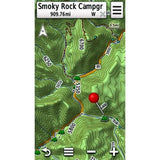
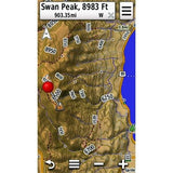
We've mapped every hill and valley for your next great adventure. Now with more detail than ever, this product covers the finer points of the outdoors with topographic maps comparable to 1:100,000 scale USGS maps. It also includes terrain contours, topo elevations, summits, parks, coastlines, rivers, lakes and geographical points.
- Provides detailed digital topographic maps, comparable to 1:100,000 scale USGS maps.
- Includes updated road content, by HERE (non-routable).
- Contains detailed hydrographic features, including coastlines, lake/river shorelines, wetlands and perennial and seasonal streams.
- Includes searchable points of interests, such as parks, campgrounds, scenic lookouts and picnic sites.
- Provides elevation profile on compatible devices so you can estimate terrain difficulty.
- Contains roads, trails and highways in metropolitan and rural areas, so getting to your destination is easy when you create point-to-point routes on compatible devices.
- Displays national, state and local parks, forests, and wilderness areas.
Please note Special order Item - Delivery Time 2 - 3 weeks
IMPORTANT: Because these maps are special order at time of purchase (made to order) they cannot be returned for refund and the transaction cannot be cancelled after we have ordered them from the manufacturer (in accordance with the Consumer Contracts Regulations). Therefore, please ensure that you are definitely ordering the correct map, and that you have checked that is compatible with your device, and that it will be delivered to you before you depart for your destination. If this means you need to contact us prior to ordering please do so.
Requirements
microSD™/SD™ Card Requirements
Make sure your device is compatible with this product before purchasing. View limitations with some marine mapping products.
To view and use the maps on this card, you must have a device with a microSD/SD card slot. Maps on a microSD/SD card require a unit to be viewed on a computer with BaseCamp™. BaseCamp™ or HomePort™, depending on the type of map.
Reduced price map updates are not available for these cards. If you want to update the maps, you must purchase a new card that includes the latest map data.
The microSD/SD card package includes a microSD card and a SD card adapter.
Coverage

Includes digital topographic maps for the entire U.S., including Alaska, Hawaii and Puerto Rico.
In the box
Micro SD card in SD Card Adaptor for safe storage
Compatible Devices
What units will this work in?
aera® 500
aera® 550
aera® 560
Alpha® 200 K
Alpha® 200i/K 5 Dog Tracking Bundle
Atemos 100
Atemos 100/K 5 Bundle
Atemos 50 and K 5
Colorado® 300
Dakota® 20
Edge® 1030
Edge® 605
Edge® 705
Edge® 800
Edge® 810
Edge® 820
Edge® Explore 820
eTrex® 20
eTrex® 20x
eTrex® 22x
eTrex® 30
eTrex® 32x
eTrex® Touch 25
eTrex® Touch 35
GPSMAP® 276Cx
GPSMAP® 62s
GPSMAP® 62sc
GPSMAP® 62st
GPSMAP® 62stc
GPSMAP® 64
GPSMAP® 64s
GPSMAP® 64st
GPSMAP 64sx
GPSMAP 64x
GPSMAP® 65
GPSMAP® 65s
GPSMAP® 66i
GPSMAP® 66s
GPSMAP® 66sr
GPSMAP® 66st
GPSMAP® 67
GPSMAP® 67i
GPSMAP® 78
GPSMAP® 78s
GPSMAP® 86i
GPSMAP® 86s
Montana® 600
Montana® 610
Montana® 650
Montana® 650t
Montana® 680
Montana® 680t
Montana® 700
Montana® 700i
Montana® 750i
Monterra®
Oregon® 450
Oregon® 450t
Oregon® 550
Oregon® 550t
Oregon® 600
Oregon® 600t
Oregon® 650
Oregon® 650t
Oregon® 700
Oregon® 750
Oregon® 750
Oregon® 750t
If you have any questions please just get in touch.


